Jul 7, 2024
Wonderland Indonesia : Volcanoes
Indonesia, located on the Pacific Ring of Fire, has numerous volcanoes. Here are some of the most notable ones:
Mount Merapi, located on the border between Central Java and Yogyakarta in Indonesia, is one of the most active and dangerous volcanoes in the world. Standing at approximately 2,930 meters (9,610 feet), it has erupted regularly since 1548. The name "Merapi" means "Mountain of Fire" in Javanese, reflecting its frequent activity.
Key points about Mount Merapi:
1. **Volcanic Activity**: It is known for its pyroclastic flows, which are fast-moving currents of hot gas and volcanic matter. These flows can be extremely deadly and have caused significant destruction in the past.
2. **Eruptions**: Some of the most significant eruptions in recent history include those in 1994, 2006, and 2010. The 2010 eruption was particularly devastating, resulting in the evacuation of over 350,000 people and causing around 353 deaths.
3. **Monitoring and Research**: Due to its active nature, Mount Merapi is closely monitored by volcanologists. The Indonesian government has established the Merapi Volcano Observatory to provide early warnings and conduct research to mitigate the risks associated with its eruptions.
4. **Cultural Significance**: Merapi holds cultural and spiritual significance for the local Javanese people. It is believed to be the home of spirits and has a place in local myths and traditions.
5. **Tourism**: Despite its dangers, Merapi attracts tourists and hikers. The surrounding region offers scenic views, and the volcano itself is a popular destination for adventurous trekkers, though access is often restricted during periods of heightened activity.
The combination of natural beauty, cultural significance, and geological activity makes Mount Merapi a fascinating subject of study and interest.
Mount Krakatau, also known as Krakatoa, is a volcanic island located in the Sunda Strait between the islands of Java and Sumatra in Indonesia. It is famous for its catastrophic eruption in 1883, which is one of the most violent volcanic events in recorded history.
Key points about Mount Krakatau:
1. **1883 Eruption**: The eruption on August 27, 1883, was cataclysmic, with the explosion being heard as far away as Australia and the island of Rodrigues near Mauritius. The eruption caused massive tsunamis, killing over 36,000 people. It also led to significant global climatic effects, with temperatures dropping worldwide and brilliant sunsets observed for several years.
2. **Formation of Anak Krakatau**: After the 1883 eruption, a new volcanic island emerged from the caldera left by Krakatau. This island, named Anak Krakatau (Child of Krakatau), began to form in 1927 and has been growing ever since. Anak Krakatau is also active, with frequent eruptions, the most recent significant one occurring in December 2018.
3. **2018 Eruption and Tsunami**: The 2018 eruption of Anak Krakatau caused a partial collapse of the volcano, leading to an undersea landslide and a resulting tsunami that affected the coasts of Java and Sumatra, killing over 400 people and injuring thousands.
4. **Geological Significance**: Krakatau is part of the Pacific Ring of Fire, an area with frequent earthquakes and volcanic eruptions. Its eruptions provide valuable insights into the processes of volcanic activity and the potential impacts of such events on the environment and human societies.
5. **Cultural and Historical Impact**: The 1883 eruption had profound effects on global weather patterns and inspired numerous literary and scientific works. It also contributed to the study of volcanic activity and disaster preparedness.
6. **Tourism and Research**: Krakatau is a popular site for scientific research and tourism. Despite its dangerous nature, the area attracts volcanologists and tourists interested in its dramatic landscape and historical significance.
Mount Krakatau's history of powerful eruptions and its continuing activity make it a significant and intriguing subject of study in the field of volcanology.
Mount Bromo is an active volcano located in East Java, Indonesia, and is part of the Tengger massif. It stands at 2,329 meters (7,641 feet) and is one of the most visited tourist attractions in the country due to its stunning landscape and cultural significance.
Key points about Mount Bromo:
1. **Geography and Landscape**: Mount Bromo is situated in the Bromo Tengger Semeru National Park. It is part of a vast caldera that also includes Mount Semeru, the highest mountain in Java. The caldera's floor is covered by a sea of volcanic sand, creating a unique and otherworldly landscape.
2. **Eruptions**: Bromo is an active volcano with frequent small to moderate eruptions. Its last significant eruptions occurred in 2010, 2011, 2015, and 2016. These eruptions typically produce ash clouds and occasional lava flows but are not as explosive as some of Indonesia's other volcanoes.
3. **Cultural Significance**: Mount Bromo holds great cultural and spiritual importance for the local Tenggerese people. They practice the Hindu religion and annually conduct the Yadnya Kasada (or Kesodo) festival. During this festival, offerings of vegetables, livestock, and money are thrown into the volcano's crater to honor the mountain gods.
4. **Tourism**: Mount Bromo is a major tourist destination, known for its breathtaking sunrise views. Visitors often climb to a viewpoint on Mount Penanjakan to watch the sunrise over Bromo and the surrounding landscape. The volcano's accessible crater rim also allows visitors to peer directly into the active caldera.
5. **Accessibility**: The area around Mount Bromo is relatively accessible, with well-developed infrastructure for tourism. Jeep tours are popular for navigating the sandy plains of the caldera, and several nearby villages offer accommodations for visitors.
6. **Bromo Tengger Semeru National Park**: The park encompasses a diverse range of landscapes, including volcanic peaks, savannas, and ancient forests. It is home to various flora and fauna, making it a site of ecological importance as well as a tourist attraction.
Mount Bromo's striking scenery, combined with its cultural richness and geological activity, makes it a fascinating and compelling destination for travelers and researchers alike.
Mount Semeru, also known as Mahameru, is the highest volcano in Java, Indonesia, standing at 3,676 meters (12,060 feet). It is an active stratovolcano and a prominent feature in the landscape of East Java.
Key points about Mount Semeru:
1. **Geographical Significance**: Mount Semeru is part of the Bromo Tengger Semeru National Park. It dominates the surrounding area with its massive height and classic volcanic cone shape, making it a significant landmark.
2. **Eruptions and Activity**: Semeru is one of the most active volcanoes in Indonesia. It has been in a state of near-continuous eruption since 1967, with frequent minor eruptions characterized by ash plumes and occasional lava flows. Significant eruptions occurred in December 2021 and 2022, causing evacuations and damage to nearby areas.
3. **Cultural Significance**: Semeru is considered a sacred mountain in Javanese culture and holds spiritual significance for local communities. It is often referred to as the "Great Mountain" (Mahameru) and is believed to be the abode of gods.
4. **Hiking and Trekking**: Mount Semeru is a popular destination for hikers and adventurers. The trek to the summit is challenging but rewarding, offering stunning views of the surrounding landscape. The journey typically starts from the village of Ranu Pane and takes two to three days. Key stops include Ranu Kumbolo, a picturesque lake, and Kalimati, a base camp for the final ascent to the summit.
5. **Flora and Fauna**: The national park surrounding Semeru is home to diverse ecosystems, including montane forests, savannas, and volcanic landscapes. The area supports a variety of plant and animal species, some of which are endemic to the region.
6. **Tourism Impact and Safety**: While the volcano attracts many visitors, it is important to note the risks associated with its activity. Authorities closely monitor Semeru's eruptions and issue warnings when necessary. Climbers are advised to stay informed about current conditions and follow safety guidelines.
Mount Semeru's combination of natural beauty, geological significance, and cultural importance makes it a compelling destination for both tourists and researchers. Its continuous activity provides valuable insights into volcanic processes and the dynamic nature of Earth's geology.
Mount Agung is an active stratovolcano located on the island of Bali, Indonesia. Standing at approximately 3,031 meters (9,944 feet), it is the highest point on the island and holds significant cultural and spiritual importance for the Balinese people.
Key points about Mount Agung:
1. **Geography and Landscape**: Mount Agung is situated in the eastern part of Bali and dominates the island's landscape. The volcano's symmetrical cone is a prominent feature, and its slopes are covered with forests and terraced rice paddies.
2. **Eruptions and Activity**: Mount Agung has a history of eruptions, with the most notable recent ones occurring in 1963-1964 and 2017-2019. The 1963 eruption was particularly devastating, resulting in over 1,000 deaths and significant damage to the surrounding areas. The volcano remains active, with frequent seismic activity and occasional ash emissions.
3. **Cultural Significance**: Mount Agung is considered the most sacred mountain in Bali and is home to the Pura Besakih, also known as the "Mother Temple." This large and important Hindu temple complex is situated on the slopes of the volcano and serves as a major pilgrimage site for Balinese Hindus.
4. **Hiking and Trekking**: The trek to the summit of Mount Agung is challenging but popular among adventurous travelers. Climbers typically start from the village of Besakih or Pasar Agung and make the ascent to the summit, which offers spectacular views of Bali and neighboring islands. The hike can take anywhere from 5 to 7 hours, depending on the route and conditions.
5. **Environmental Impact**: Eruptions of Mount Agung can have significant environmental impacts, including ash fall, pyroclastic flows, and lahars (volcanic mudflows). These events can disrupt air travel, agriculture, and local communities. The volcano's activity is closely monitored by the Indonesian Center for Volcanology and Geological Hazard Mitigation.
6. **Tourism and Safety**: While Mount Agung is a popular destination for trekkers, it is important to be aware of the potential risks associated with its activity. Local authorities provide updates on volcanic activity and issue warnings when necessary. Tourists are advised to heed these warnings and follow safety guidelines.
Mount Agung's combination of natural beauty, spiritual significance, and geological activity makes it a fascinating destination for visitors and an important subject of study for volcanologists. Its eruptions and ongoing activity highlight the dynamic nature of the Earth's geology and the need for careful monitoring and preparedness.
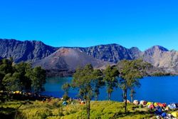
Mount Rinjani is an active stratovolcano located on the island of Lombok in Indonesia. Standing at approximately 3,726 meters (12,224 feet), it is the second-highest volcano in Indonesia and a prominent feature in the landscape of Lombok.
Key points about Mount Rinjani:
1. **Geography and Landscape**: Mount Rinjani is part of the Rinjani-Lombok National Park, which covers an area of around 41,330 hectares. The volcano features a large caldera with a crater lake called Segara Anak (Child of the Sea), which is about 6 kilometers wide. Within this lake is a small volcanic cone known as Barujari or "New Mountain."
2. **Eruptions and Activity**: Rinjani is an active volcano with a history of eruptions. Notable eruptions include those in 1994, 2004, 2009, 2010, and 2016. These eruptions often result in ash plumes and occasional lava flows. The most recent significant activity was in 2018, which caused temporary closures of the trekking routes due to safety concerns.
3. **Cultural Significance**: Mount Rinjani holds cultural and spiritual importance for the local Sasak people and Balinese Hindus. The Segara Anak lake is considered sacred, and local traditions include offering ceremonies to honor the spirits of the mountain.
4. **Hiking and Trekking**: Mount Rinjani is a popular destination for trekkers and adventure seekers. The trek to the summit is challenging and typically takes two to three days. Hikers can start from the village of Sembalun or Senaru. The journey includes traversing diverse landscapes such as rainforests, savannas, and volcanic terrain, with stops at the crater rim and Segara Anak lake. The views from the summit and along the route are breathtaking.
5. **Flora and Fauna**: The national park surrounding Mount Rinjani is home to diverse ecosystems and wildlife. It includes tropical forests, grasslands, and alpine meadows. The area supports various plant and animal species, some of which are endemic to Lombok.
6. **Environmental Impact**: Eruptions and volcanic activity can significantly impact the environment and local communities. Ash fall, lava flows, and pyroclastic flows can disrupt daily life, agriculture, and air travel. The volcanic activity is closely monitored by Indonesian authorities to provide early warnings and ensure the safety of residents and visitors.
7. **Tourism and Safety**: Mount Rinjani's trekking routes are well-established, with numerous guides and tour operators offering services. However, due to the challenging nature of the hike and the volcano's activity, trekkers are advised to be well-prepared and heed safety guidelines. It is essential to check for updates on volcanic activity and trail conditions before embarking on a trek.
Mount Rinjani's combination of stunning natural beauty, cultural significance, and geological activity makes it a captivating destination for both tourists and researchers. The challenging trek to its summit offers an unforgettable experience, showcasing the diverse and dramatic landscapes of Lombok.
Mount Sinabung is an active stratovolcano located in North Sumatra, Indonesia. It is part of the Sunda Arc, a volcanic arc that forms the backbone of the Indonesian islands.
Key points about Mount Sinabung:
1. **Geography and Landscape**: Mount Sinabung stands at approximately 2,460 meters (8,070 feet). It is situated in the Karo Plateau of North Sumatra, surrounded by fertile agricultural land. The volcano's slopes are often covered with lush vegetation, although frequent eruptions have left parts of it barren.
2. **Eruptions and Activity**: Sinabung was dormant for several centuries before erupting in 2010. Since then, it has been highly active, with significant eruptions occurring in 2013, 2014, 2016, and 2018. These eruptions have produced pyroclastic flows, lava domes, and ash plumes, causing extensive damage to nearby communities and agriculture.
3. **Impact on Local Communities**: The frequent eruptions of Mount Sinabung have had severe impacts on local populations. Thousands of people have been displaced, and entire villages have been buried by volcanic material. The Indonesian government has established exclusion zones around the volcano to ensure the safety of residents, and ongoing relief efforts are in place to support affected communities.
4. **Monitoring and Research**: Due to its heightened activity, Mount Sinabung is closely monitored by the Center for Volcanology and Geological Hazard Mitigation (PVMBG) in Indonesia. Volcanologists use various methods, including seismic monitoring and satellite imagery, to track the volcano's activity and provide early warnings to mitigate the impact of eruptions.
5. **Environmental Impact**: Eruptions from Sinabung have significantly altered the landscape and environment around the volcano. Ash fall has damaged crops, contaminated water sources, and affected air quality. The repeated eruptions have also led to the formation of new geological features, such as lava domes and pyroclastic deposits.
6. **Tourism**: Despite its dangers, Mount Sinabung attracts some tourists and researchers interested in its volcanic activity. However, due to safety concerns, access to the immediate area around the volcano is often restricted, especially during periods of heightened activity.
7. **Preparedness and Education**: The ongoing activity of Mount Sinabung has led to increased efforts in disaster preparedness and education in the region. Local authorities and organizations work to educate residents about volcanic hazards and emergency response measures to reduce the risks associated with living near an active volcano.
Mount Sinabung's reawakening and continuous activity have provided valuable insights into volcanic processes and the challenges of living in volcanic regions. Its impact on local communities and the environment underscores the importance of effective monitoring, disaster preparedness, and mitigation efforts.
Mount Tambora is a massive stratovolcano located on the island of Sumbawa in Indonesia. It is most famous for its catastrophic eruption in 1815, one of the largest and most powerful eruptions in recorded history.
Key points about Mount Tambora:
1. **Geography and Landscape**: Mount Tambora stands at approximately 2,850 meters (9,350 feet) today, though before the 1815 eruption, it was estimated to be about 4,300 meters (14,100 feet) high. The eruption dramatically reduced its height and formed a large caldera, approximately 6 kilometers (3.7 miles) wide and 1,100 meters (3,600 feet) deep.
2. **1815 Eruption**: The eruption of Mount Tambora in April 1815 is considered one of the most powerful volcanic events in recorded history. It reached a Volcanic Explosivity Index (VEI) of 7. The eruption ejected an estimated 160 cubic kilometers (38 cubic miles) of material into the atmosphere. The explosion was heard as far away as Sumatra, over 2,000 kilometers (1,200 miles) away.
3. **Impact on Local and Global Climate**: The eruption had devastating local effects, killing an estimated 71,000 people, many due to starvation and disease following the initial explosion and pyroclastic flows. Globally, the vast amounts of volcanic ash and sulfur dioxide injected into the stratosphere caused significant climatic changes, leading to what is known as the "Year Without a Summer" in 1816. This resulted in widespread crop failures and food shortages in the Northern Hemisphere.
4. **Environmental Impact**: The eruption caused extensive damage to the environment around Tambora. It destroyed vegetation and animal life within a large radius, and the ash fall created barren landscapes. The climate effects led to unusually cold weather and disrupted agricultural cycles worldwide.
5. **Volcanic Monitoring and Research**: Modern monitoring of Tambora includes seismographs and satellite observations to track any signs of renewed activity. Researchers study the deposits left by the eruption to understand more about the dynamics of such massive volcanic events and their far-reaching effects.
6. **Tourism**: Today, Mount Tambora is a popular destination for adventure tourism and scientific study. Trekkers can explore the caldera and its unique landscape, and the area is part of a national park established to preserve its natural and historical significance. The trek to the caldera rim is challenging but offers spectacular views of the surrounding area.
7. **Historical Significance**: The 1815 eruption of Tambora is a key event in the study of volcanology and climate science. It provided early evidence of the significant impact that volcanic eruptions can have on global weather patterns and ecosystems. The eruption also had historical and cultural implications, influencing art, literature, and social conditions in the early 19th century.
Mount Tambora's 1815 eruption stands as a stark reminder of the power of volcanic activity and its potential to affect the planet on a global scale. The lessons learned from studying Tambora continue to inform disaster preparedness and climate research today.
Mount Kelud, also known as Gunung Kelud, is a volcano located in East Java, Indonesia. It is known for its explosive eruptions and has been one of the most active volcanoes in the country. Here are some key points about Mount Kelud:
1. **Location:** Mount Kelud is situated in East Java, Indonesia, near the city of Blitar.
2. **Eruptions:** It has a history of violent eruptions, with notable ones occurring in 1919, 1951, 1966, and more recently in 1990, 2007, and 2014.
3. **2014 Eruption:** The 2014 eruption was particularly significant, resulting in the evacuation of tens of thousands of people from the surrounding areas. It ejected ash and volcanic debris over a wide area, affecting local communities and agriculture.
4. **Volcanic Features:** Kelud has a crater lake known as Kawah Kelud (Kelud Crater), which is known for its scenic beauty but also poses potential hazards during eruptions.
5. **Monitoring:** Due to its active nature, Mount Kelud is closely monitored by Indonesian authorities to provide early warnings and evacuation plans in case of future eruptions.
6. **Impact:** Eruptions of Mount Kelud can impact air travel due to ash clouds and pose risks to nearby communities from pyroclastic flows and lahars (mudflows).
Overall, Mount Kelud is significant both geologically and culturally in Indonesia, highlighting the ongoing volcanic hazards faced by the region.
Mount Ijen, also known as Gunung Ijen, is another notable volcano located in East Java, Indonesia. Here are some key facts about Mount Ijen:
1. **Location:** Mount Ijen is situated within the larger Ijen Caldera complex, near Banyuwangi Regency in East Java, Indonesia.
2. **Volcanic Features:** It is known for its large acidic crater lake, Kawah Ijen, which is one of the largest in the world. The lake is turquoise in color due to its high acidity and dissolved minerals.
3. **Sulfur Mining:** One of the unique aspects of Mount Ijen is the presence of sulfur mining operations within the crater. Miners extract sulfur deposits manually, enduring harsh conditions and toxic fumes. The sulfur is used in various industrial processes.
4. **Scenic Beauty:** Mount Ijen is renowned for its stunning landscapes, especially during sunrise when the turquoise lake and surrounding volcanic terrain are illuminated by the early morning light.
5. **Hiking and Tourism:** It is a popular destination for tourists and hikers, offering trekking opportunities to view the crater lake and sulfur mining activities. The hike to the crater rim can be challenging but rewarding.
6. **Volcanic Activity:** While Mount Ijen is not as frequently eruptive as some other volcanoes in Indonesia, it remains an active volcano with occasional phreatic eruptions and gas emissions.
7. **Environmental Concerns:** The sulfur mining operations and tourism have raised environmental concerns, particularly regarding the impact on the fragile ecosystem and the health risks faced by the miners.
Overall, Mount Ijen is a fascinating and unique volcanic landscape, offering both natural beauty and insights into the human interaction with volcanic environments.
By undefined
32 notes ・ 4 views
English
Elementary